Locating Vulnerable Populations
Can machine learning and aerial imagery be used to detect unhoused populations in high-risk disaster zones in Los Angeles County?
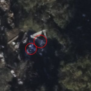
For my Master's project my team and I used aerial imagery and deep learning models to detect locations where vulnerable and unhoused populations are located, especially in areas of fire and flood risk. I worked with Vexcel Imaging, an aerial imaging company, to use their data to create a series of unsupervised, machine learning, and spectral approaches to segment, detect, and classify tents or encampments in wildfire risk areas. Python libraries used for these processes included OpenCV, Matplotlib, and Numpy. Our final model included two main components - a mask of spectral information including a conversion from RGB to HSV, and a blob detection process using computer vision to identify tents from their surroundings.
I also worked with Esri ArcGIS Pro's deep learning tools to detect tents, ENVI's supervised classifications, and eCognition to run segmentation. I used the Python libraries GDAL and Rasterio to apply our techniques to other imagery sources and then to georeference our results for further spatial analysis.